
During regular riding season (which is just around the corner!) Sport Touring Corner will concentrate on multi-day trips and rallies, but most sport touring riders with little vacation time and have to get most of their riding enjoyment from short rides of a day or less, limiting them to a one or two hundred mile radius from home.
Even though I’m free to travel during the rally season from April through October, there is still another five months in the off-season that includes some relatively nice days even during Winter for day rides.
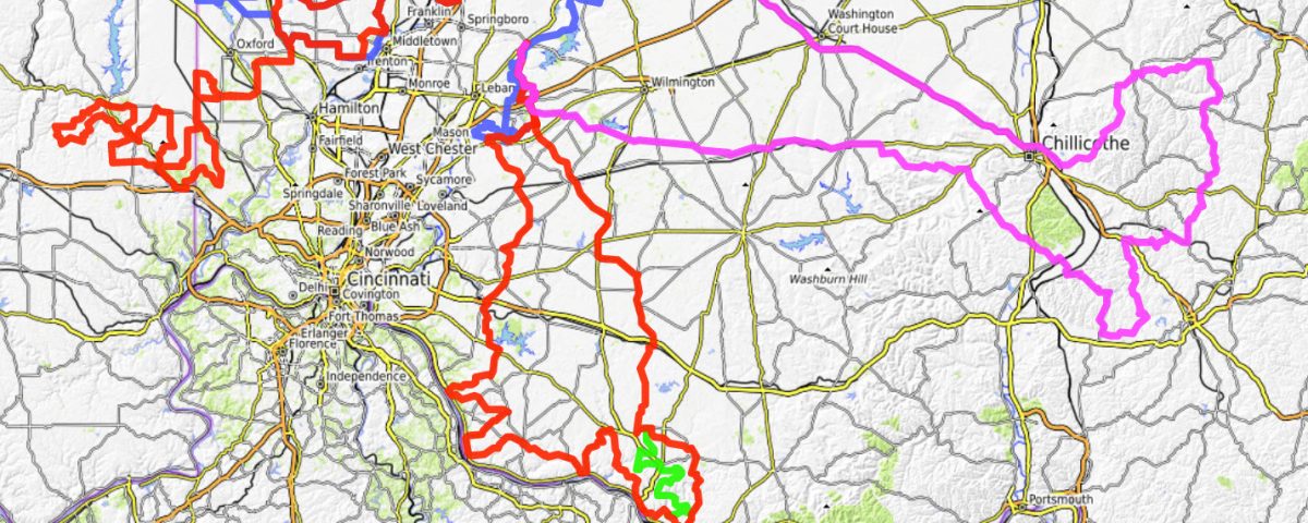
Ohio has plenty of twisty roads, but they are not evenly distributed across the state. 2203-01.jpg It’s pretty easy to see why we like the Marietta, Ohio, in the Southeast corner of the map, which is the home of Motorcycle Sport Touring Association’s FlyBy Week, but if you look at the Dayton, Ohio area where I live, those of us who like twisties have to dig a bit to find them nearby.
Finding Twisty Roads
If the land around you is relatively flat, country roads are going to be arranged in a boring grid pattern, with 90 degree turns here and there based on property lines. Fortunately, rivers and creeks were there before civilization and follow the contours of the land, meandering even in flat areas.
Waterways were often the best way to move people and goods before a network of roads could be built. When roads were built they tended to follow rivers as they were the established paths of commerce. Rural roads tended to follow creeks, as they were a natural path. Bridges to cross them cost money so roads often follow them long distances to points that are easier to cross. Larger rivers are straighter, but they carve valleys with tributaries. Roads that along the tributaries often give you elevation changes along with the curves. Looking at the area South of Dayton (there is nothing but flat farmland to the North), there are just scattered twisty roads to the West. Heading South, (going just far enough East to avoid the big urban areas) things get better quickly. The hilly areas on the North side of the Ohio river, all the way from New Richmond to East of Portsmouth provide plenty of twisties to explore.
I found this info in the maps at https://roadcurvature.com where there are downloadable files for every state and most foreign countries. The files are in KMZ format for Google Earth but require conversion to GPX format for most route planning apps, so I did conversions for Ohio and Indiana and posted them on my new Norms Rides website below. The Curvature GPX files can be downloaded from my web page, imported into Garmin BaseCamp and used as a guide for route planning.
I changed the color of the twisty roads to blue to contrast BaseCamp’s default magenta route color. Now I can create new routes, knowing where the twisty roads are and recognizing easy ways to connect them.
Since I have not ridden most of these roads- some might be gravel, not all public and some to not actually go through- they are not recommendations. They are merely roads to explore. When riding them I will mark the good ones with waypoints on the GPS for future reference. Later in BaseCamp I can use that info to change the color of the good roads and delete the bad ones.
Some areas of the map have few blue roads. These are flat farming areas with relatively straight roads in a more rectangular grid pattern. They can be ridden pretty quickly to get to more interesting stuff.
In addition to the Curvature files, the new Norms Rides website at https://norms-rides.flybyweek.com/ features my “Favorite Five” local routes with full descriptions, maps and downloadable GPX files. 2203-03.jpg
Here’s a quick summary:
The 01 East Short Ride 95 miles goes to Jamestown, Ohio and down a bit of the Little Miami River valley through Oregonia and Morrow.
The 02 Indiana Border & Back Ride 96 miles takes you over to the Indiana border and back, touching Hueston Woods State park.
The 03 Brookville Indiana Ride 206 miles takes you to Brookville, Indiana, where the hills along the Whitewater River valley provide lots of fun roads that can be ridden in different combinations.
The 04 Ripley OH Lunch Ride 206-214 miles with lots of fun roads in the hills near the river between New Richmond and Aberdeen. The lunch stop in Ripley at the Dairy Yum Yum is a favorite. The Twisty return route features fantastic Ohio route 763, but if you like hilly winding county roads the Technical return route is the best choice.
The 05 Ridge Inn Ohio Lunch Ride 255 miles requires decent weather and an early start. There’s a wide variety of twisties and technical roads all the way to Hocking Hills with lunch at the Ridge Inn in Laurelville, Ohio. Us Route 35 from Chillicothe to Xenia is used for the return trip to save time.
Check out Norms Rides at https://norms-rides.flybyweek.com/
——————————————————————–
Connect with local Ohio MSTA riders at these monthly breakfasts:
Southwest Ohio Breakfast, 9AM March 19
Village Family Restaurant
144 S. Main St.
Waynesville, OH 45068
Central Ohio Breakfast Meet – Sunday April 3. Arrive at 8 am to eat, 9 to ride if weather permits.
Portside Cafe
6515 S High St
Lockbourne, OH 43137


